
Kaplan, LA 102.2m***
 April 30, 2001
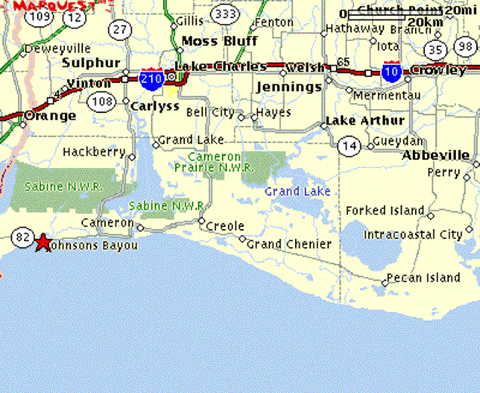
Holly Beach is just below the m in Cameron on the map above. It seems like its on land, but this is a land of, for lack of a better word, swamps. Theres water all over the place. 82 seems like a road going through the outer banks of North Carolina.
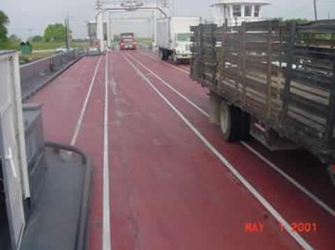
The easterly winds were brisk at daybreak. It was humid and sunny. Even with the wind, I had to change lanes to avoid swarms of mosquitoes. (My room at Roys Cabins last night had a hole in the floor, which I discovered as I was packing up this morning, and I got about 20 bites on my arms mostly last night.). 10 miles down the road I came to the ferry crossing at Calcasieu Ship Canal (Im sure this huge river has some other name). Some cars and I waited for it. It approached. Cars left and reloaded (about 10 cars and 4 semis), and we crossed. The visuals:


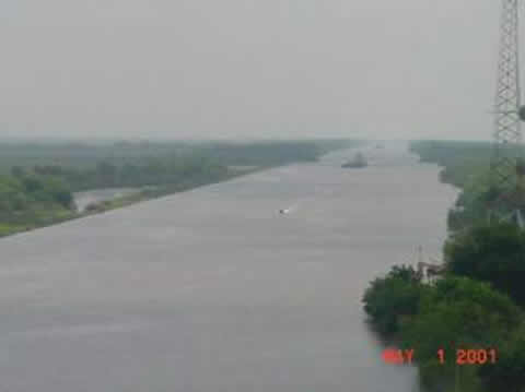
The other side was Cameron, LA, and Im glad I didnt get a chance to stay at one of the many cheap hotels. Cameron exists to support the oil and fishing business. If you need more information from https://renegadewls.com/ this site. Its a working town with a lot of hard working people, helicopters (Id say a couple dozen), and ships. Heres a view of some of the ships on the river, and one of a ship of indeterminate purpose.


There were bunches of shrimpers and of these types of boats.
I did have breakfast in Cameron, and read the Cameron Pilot, the local daily. Not a word about anything outside Cameron parish in the paper. I did learn that the wind was shutting down the red snapper fishing (apparently the current sport fishing gig). Only the largest boats were getting out, and they were reporting very rough conditions. Other stories on the school board, regulation of the Pilots, tax revenues from natural resources, etc.
My goal was to stay on 82 through the swamps, cutting north at Pecan Island, through Perry to Abbeyville (orange line on map). However, after 2 hours of riding into the wind, I was averaging only 10.3 mph (very slow considering how incredibly flat this place is), and I was going nuts. So, I decided to hang a left at Creole, head 20 miles inland, and then head east. (Wind was a sufficient reason alone, but there were others including desolation, mosquitoes and road kill (see below)).
It was nice heading north on 27 (for some reason there are two LA27s in Cameron Parish that both head north from 82 – this is the one that goes through Creole, the red line on the map). Up to 14-15 mph. The only sight was miles of flat swamp, till I got to the intercoastal waterway. Heres the bridge, the view looking SE at the swamps, and a view of the waterway.


(note the straight road heading south that I just rode up on.. on the map thats land all around, but as you can tell, its a land of water.)
I also saw I sign that said Inmates Ahead, and lo and behold, there they were, picking up trash, followed by a slowly moving convoy of support vehicles.
![]()

I joined LA14 east of Bell City, and rejoined the wind. All day long I was on 2 lane roads, without shoulders. It was a mixture of cow pastures (they get about 200 square feet here vs. 200 acres in West Texas), lots of rice paddies, and more swamps – these ones often with trees.

Pretty, huh?
We got back to fighting that persistent wind. I averaged only 11.2 mph while on the bike all day. Parts of the afternoon here I couldnt get up to 10 mph. As such, this planned high mileage day came in very low (102.2). Heading east I went though a few inconsequential towns, mostly with a little convenience/grocery store as the only commercial establishment (usually without gas). Never made it to Abbeyville. But I did get a shot of the town sign before Kaplan and the town sign of Kaplan.

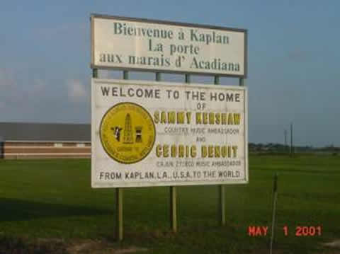
Ive been skipping the town signs because there are too many of them around here, and because most of them are too boring – but I couldnt pass up the Duck Capital of America.
Thats pretty much it, except for road kill. If you dont want to hear about it, look at the picture of the caterpillar crossing the road (he turned toward the camera when I set it down next to him), and then close the file. (For all you sickos, there are no pictures of road kill following.)

The take aways from the picture are that the roads in Louisiana are not too smoothly paved, and that this guy (I saw many of them crossing roads, usually N to S) is taking a big chance.
I didnt write about it, but the day I left Del Rio (to Gonzales?) was unofficially Butterfly Day. There were hundreds of them, mostly small, of many different colors. A pretty day.
Id designate today as road kill day, and Creole LA as the road kill capital of the world. Ive been avoiding the subject for obvious reason, but today, within 10 miles or so both sides of Creole, I saw 7 dead alligators and countless turtles, snakes, armadillos, possums, birds (of many different kinds), rabbits, squirrels, raccoons, lizards and brown furry mammals that I couldnt recognize (about the size of the raccoons). It was incredible. You couldnt go more than 100 feet without dead stuff. I can understand a smushed turtle, but how people can run over a 5 foot alligator is beyond me.
Thats it. I havent checked the schedule for tomorrow yet, but I know that, perhaps for the first time, I am behind schedule due to this stupid, stupid wind.
