Palmeira 114k, 71m***
 September 30, 2004
There’s an election going on down here too – a little different from Kerry vs. Bush. Politics in Brazil is based on loudspeakers, billboards and flags. Candidates are identified on the ballot by their name, a number (two digits in rural areas, 5 in urban), and a picture.
The loudspeakers are most often on moving vehicles, usually displaying flags and/or mobile billboards. When they’re not playing passionate speeches, they are playing very, very loud, music. The candidate’s numbers are displayed NASCAR style on bumper stickers.
The flags are often waved by people in intersections in front of traffic stopped at the red lights, but they could be on cars, bikes, in marches (see yesterday), or just plain flagpoles. The billboards or posters are everywhere.
As I write this at 10:45p, “they” have blocked off the main street in this rural town (35,000 people) for a stage where the main loudspeakers are blaring with speeches. I have no idea what they’re screaming about – it’s all Portuguese to me. The responsible parties have also put up trampolines in nets and are serving free cotton candy to attract the kids to attract the parents to the main political rally.
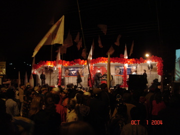
The opposition is undaunted, driving around in amp’ed up cars and trucks with blaring music and speeches to interfere with the main rally. The Palmeira Clima Hotel (the only hotel in town) where we are staying literally vibrates when one drives past. Sleep?
…
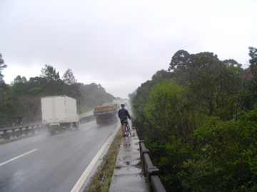
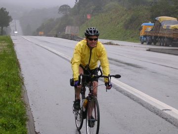
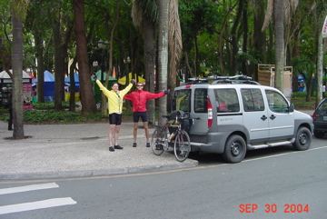
We rode our bikes here, starting from 60km the other side of Curitiba. Eduardo drove us back in the 52-degree rain, and we could see our breath as we rode off. Heading back to Curitiba it was more huge, rolling hills. Many of them had treacherous bridges, for bikers that is, at the bottom. The lack of shoulders and guardrails on the heavily truck trafficked BZ116 forced us to not only lose momentum, but get off our bikes and tightrope across the bridges.
As I write this in the vibrating hotel without heat, Kerry and Bush are debating in Spanish at the Internet café next door, and Dalton is astonishingly asleep.
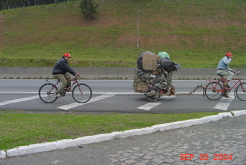
Bikes, none of them flashy but most dependable, do a lot of work here in Brazil. These guys slowed me up down a great downhill,.
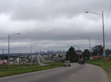
By eleven we made it back to Curitiba. The road heading into town:
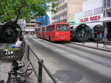
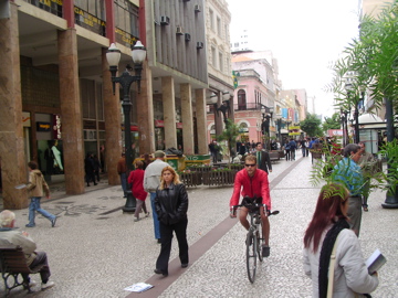
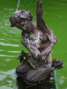
Rather than riding around the city, we rode through it. Here is one of their bus stops, Dalton riding on one of the pedestrian walkways, a statue (great picture by Dalton) in one of the park fountains and us celebrating the town. As I said yesterday Dalton and I want to move here (and drive around the Fiat). Read more later in this update about Curitiba.
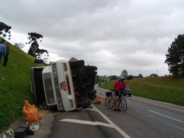
The weather, detour back into Curitiba and all this fun took a chunk out of the day. We pressed on out of town into the countryside, back into the rolling hills plus one beautiful but long and difficult climb from 2,700 feet to 3,500 feet. The trucks we’re playing chicken with us, and Dalton got pissed so he kind of swerved in front of one which caused it swerve, flip and slide on its side along the pavement. Here he is examining his work.. Good job Dalton!
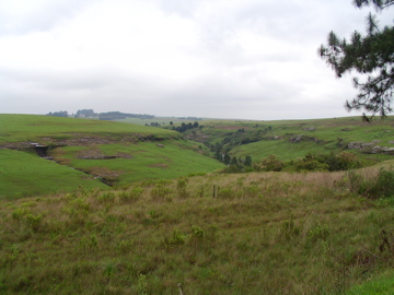
We left before the police came. Here is a countryside view from our afternoon ride. The met-Atlantic (sp?) forests are gone, replaced by something Dalton thinks looks like Wyoming in the summer. There’s no wilderness here. It’s all developed to some degree.
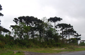
The funky looking trees above are the state symbol of Paraná, the Brazilian state south of Sao Paulo state (same name as city) which we are riding through now.
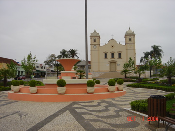
Eventually after losing Eduardo again for maybe 3 hours, we reconnected and rode into Palmeira and the political activity. The town has 35,000 people and seems well organized on a main road leading to a beautiful town square.
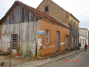
Most of the buildings, however are not in such great shape – here is a typical one.
Everyone here is bundled up against the 50 degree cold. If the frigging politics and music would stop, I could get some sleep and get ready for our 7am Day 4 departure… somehow Dalton and Eduardo manage…
MORE ON CURITIBA (if you’re interested)
Curitiba is a city in Brazil, the capital of the state of Paraná. In 2001 it had a population of some 1,600,000 people. It is on a plateau 3,120 feet above sea level. It is 65 miles west of the sea port of Paranaguá,
History
The name “Curitiba” comes from the Tupi word Curii Tiba, “pine”, due to the high concentration of pine trees previously in the region. The Portuguese who founded the city in 1693 gave it the name of “Vila Nossa Senhora da Luz e Bom Jesus dos Pinhais” (Our Lady of the Light of the Pines). The name was changed to “Curitiba” in 1721.
Curitiba officially became a city in 1842. Growth was based on trade, leasing of winter homes, and offices for cattle traders. In 1854, Curitiba became the capital of the state of Paraná in 1853. Schools and theaters were built.
In 1870, the first European immigrants, mostly Germans, Poles, and Italians, arrived in Curitiba. A smaller number of Japanese, French, English, and Swiss immigrants also established colonies near the city, mainly devoted to agriculture and traditional craftwork.
In 1913, the Universidade Federal do Paraná, the first of its kind in Brazil, was built, along with the electrification of streetcars.
Planning
Curitiba is held as a paragon of urban planning excellence. The city has a notably efficient transportation system, including devotion of lanes on major streets for a bus rapid transit system. The buses are long, split into three sections, and stop at designated elevated tubes, complete with handicapped access. The system, used by 85% of Curitiba’s population, is similar to the TransMilenio in Bogotá, Colombia. The city is also remarkably successful in preserving and caring for its green areas, boasting 54 sq mt of green space per inhabitant.
By the 1960s, Curitiba’s population had ballooned to 430,000, and some residents feared that the growth in population threatened to drastically change the character of the city. In 1964, Mayor Ivo Arzua solicited proposals for urban design. Architect Jaime Lerner, who later became mayor, led a team from the Universidade Federal do Paraná that suggested strict controls on urban sprawl, a reduction in traffic in the downtown area, preservation of Curitiba’s Historic Sector, and a convenient and affordable public transit system. This plan, known as the Curitiba Master Plan, was adopted in 1968. Lerner closed Rua XV de Novembro, one of the main streets, to traffic and adopted a new road design to minimize traffic. This design, called the Trinary Road System, uses two one-way streets moving in opposite directions which surround a smaller, two-lane street.
In the 1980s, the Rede Integrada de Transporte (Integrated Transport Network) was created, allowing transit to any point in the city by paying just one fare. The city also begun an interesting project called the “Faróis de Saber” (Lighthouses of Knowledge). These Lighthouses are free educational centers which include libraries, Internet access, and other cultural resources.
Today, Curitiba is considered one of the best examples of urban planning on the planet. In June 1996, the chairman of the Habitat II summit of mayors and urban planners in Istanbul praised Curitiba as “the most innovative city in the world.”
(thanks to Erica for the research)
